MapPad GPS Land Surveys 7.5.0
Free Version
Publisher Description
MapPad GPS Land Surveys - Measure distance and area using map or GPS - share your results the easy way…
Use MapPad to calculate areas, perimeters and distances and save, export or share your measurements.
MapPad is providing multi-purpose mapping solution allowing location capture and determines distance and area for the shapes drawn on the map or captured using real-time GPS tracking.
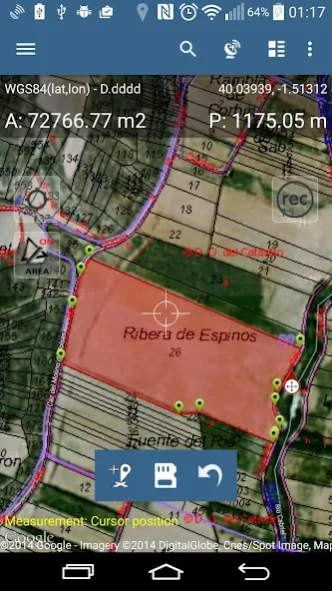
Calculate area of the field or a walk distance instantly using Google or Bing Map Satellite view. Save petrol and time and capture features with few clicks on the map.
With MapPad you can capture, manage and share your data easily.
MapPad is a very useful tool for anyone involved in forestry, agriculture, engineering and real estate management.
Please visit our website to find out how to prepare offline map and get more information about this product.
Selected features:
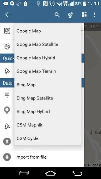
- Base maps: Google Maps, Open Street Map, Bing Maps
- Google Maps Overlays (Custom WMS or ArcGIS Server Tiled service), some layers like US Topographic map have been predefined.
- Very accurate measurement of areas and distances.
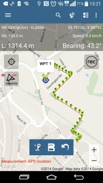
- 3 methods of measurement are supported (Tap on the map, GPS location, Map cursor location).
- Support for number of metric and imperial units.
- Support for several global and local coordinate systems, if you require support for any other spatial reference please get in touch.
- Possibility to capture waypoints and group them in categories.
- Possibility to add or edit title and description for each recorded measurement and waypoint.
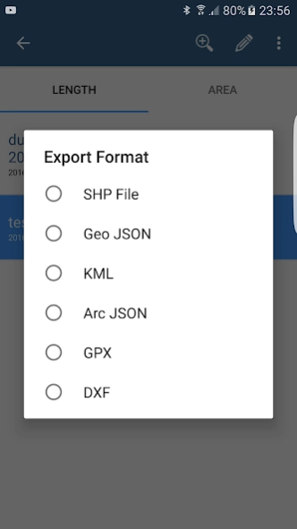
- Export single or multiple measurements or waypoints to SHP File, Geojson, ArcGIS Json, KML, GPX, CSV and DXF to SD Card or cloud services las well as direct export to Open Street Map.
- Share single waypoint location directly by SMS, E-mail or other ways.
- Elevation profile available for measurements done by GPS.
- Import of KML and GPX files to the application.
- GPS status and satellites status.
- Address, location search.
- Quick open exported KML files in Google Earth
- Ability to set default measurement units, waypoints' categories colours, track recording time and distance interval, transparency of Google Maps overlays and much more...
Our users are successfully using MapPad in number of projects and applications.
About MapPad GPS Land Surveys
MapPad GPS Land Surveys is a free app for Android published in the PIMS & Calendars list of apps, part of Business.
The company that develops MapPad GPS Land Surveys is Mapit GIS LTD. The latest version released by its developer is 7.5.0. This app was rated by 2 users of our site and has an average rating of 4.0.
To install MapPad GPS Land Surveys on your Android device, just click the green Continue To App button above to start the installation process. The app is listed on our website since 2019-03-08 and was downloaded 144 times. We have already checked if the download link is safe, however for your own protection we recommend that you scan the downloaded app with your antivirus. Your antivirus may detect the MapPad GPS Land Surveys as malware as malware if the download link to com.osedok.mappad is broken.
How to install MapPad GPS Land Surveys on your Android device:
- Click on the Continue To App button on our website. This will redirect you to Google Play.
- Once the MapPad GPS Land Surveys is shown in the Google Play listing of your Android device, you can start its download and installation. Tap on the Install button located below the search bar and to the right of the app icon.
- A pop-up window with the permissions required by MapPad GPS Land Surveys will be shown. Click on Accept to continue the process.
- MapPad GPS Land Surveys will be downloaded onto your device, displaying a progress. Once the download completes, the installation will start and you'll get a notification after the installation is finished.
